
My surveying career taught me that a productive detecting site is rarely just an old place on a map. The useful clues come from connecting ownership history, occupation length, buildings, boundaries, and how people actually used the ground. I learned that lesson twice: first when old records led me to a farmstead that produced pre-1920 coins and two silver rings, and again when other documented properties produced very little. The records do not promise finds, but they can replace a random search with a reasoned decision about where to ask permission and where to start looking.
What My Surveying Work Taught Me About Finding Metal Detecting Sites
In 30 years as a county land surveyor, I read tens of thousands of deed descriptions, plat maps, and boundary surveys. Every one of those records described more than property lines. Taken together, they showed where people lived, what they built, how parcels changed hands, and which parts of the land remained important long enough to be recorded again and again.
When I picked up a metal detector after retiring, I realized I had been researching potential detecting sites for most of my career without calling it that. Survey work had trained me to look past the current appearance of a property. An open field may once have held a house, a lane, a barn, or a gathering place, while an impressive old building may sit on ground that was disturbed, filled, graded, or occupied for only a short period.
This article is the story of how that professional habit changed the way I choose locations. It is not a full map-reading course, a legal guide, or a step-by-step permission script. Those subjects deserve more room than a personal account can give them. The point here is narrower: records become useful when they help explain human activity, not merely age.
A Deed Chain Shows Time, Not Just Ownership
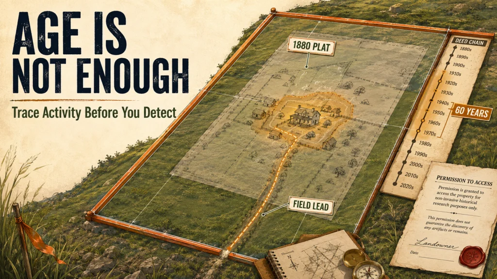
In county surveying work, tracing a deed chain is a normal part of understanding how a present boundary came to exist. I would work backward from the current deed through earlier conveyances, sometimes reaching the original land grant or an early division of a much larger tract. The legal purpose was to establish boundary history, but the same sequence also revealed when a family arrived, how long the property stayed intact, and when the land was divided among later owners.
That time element matters to a detectorist because occupation leaves a pattern. A family associated with a farm for 60 years had far more opportunities to lose coins, buttons, buckles, jewelry, and small household objects than a tenant who stayed for three years. The record does not tell me that a specific object is in the ground. It tells me whether there was enough repeated activity to justify taking the next research step.
| What the record shows | What I ask as a detectorist | What the record cannot prove |
|---|---|---|
| A long period of family ownership | Was the property continuously occupied during that period? | That coins or relics remain in the soil |
| A house or farmstead on an older plat | Where did daily movement occur around the structure? | That the mapped structure stood in exactly the same spot for its entire life |
| Repeated parcel divisions | Did roads, lanes, fences, or activity areas move as the tract changed? | That the modern boundary matches the historical use area |
| A historically old parcel | How intensively was it used, and for how long? | That every old acre is equally promising |
The distinction between ownership and occupation is easy to miss. A deed may preserve a name for decades even when the family lived elsewhere, leased the farm, or used only part of the parcel. That is why I do not treat a long deed chain as a green light by itself. I use it to form a better question, then look for maps and other records that show where the activity was concentrated.
The Old Plat That Turned an Open Field Into a Real Lead
My first deliberate use of surveying knowledge for detecting began with an 1880 county plat atlas. I overlaid the old atlas with current satellite imagery and found a farmstead structure marked on a parcel that now appeared to be open field. Without the older record, there was nothing in the modern view that would have made the location stand out.
I approached the landowner and explained that I had worked as a surveyor and had found a reference to the property in county records. That changed the conversation. I was not knocking on the door with a vague claim that the place looked old. I could explain what I had found, why I believed a former homesite had been there, and what area I wanted permission to examine.
I had permission within five minutes. On the first visit, the site produced coins dating from before 1920 and two silver rings. Those finds confirmed that the mapped farmstead had been more than a cartographic mark, but the more useful lesson was how the lead developed: the old atlas identified the former structure, the modern image helped place it on the present parcel, and the county record gave me a credible way to discuss the property with its owner.
Field Note: The landowner did not grant access because an old map guarantees valuable finds. The record made my request specific and showed that I had taken the property seriously before asking. Permission is still the owner’s decision, and every hunt on private land requires clear approval for the exact property and activity involved.
That experience shaped the way I now think about metal detecting map research tools. A tool earns its place when it answers a different part of the location question. One source may show ownership, another may show a vanished building, and another may help align an old road with the current landscape. Collecting maps is not the goal. Resolving uncertainty is.
What I Got Wrong About Historically Documented Places
After that successful farmstead, I made the mistake many researchers make after one strong result. I began to assume that a documented historical location was automatically a worthwhile detecting location. The logic sounded reasonable: if an old house appeared on a map, people had lived there, and objects must have been lost.
The missing variable was occupation intensity. A plat or deed chain can establish presence, but presence is not the same as repeated daily use. A family that occupied a property for several generations created a different target environment than a short-term resident, a seasonal tenant, or an owner who held the land while living somewhere else.
That correction changed my research standard. I stopped asking only, “Was someone here?” and began asking, “What happened here often enough to leave a recoverable pattern?” A home occupied for decades, a route repeatedly walked between a house and outbuildings, or a yard used by several generations may justify more attention than an older but lightly used structure.
The difference also explains why a promising property can produce nothing on a first visit. The mapped location may be slightly off. The original surface may have been graded or covered. The most active ground may lie beside the structure rather than under it. Previous detecting, erosion, fill, and later construction can all change what remains. Historical documentation improves the odds of choosing intelligently, but it does not remove field uncertainty.
The Surveyor’s Habit I Still Use Before a Hunt
Surveying taught me not to trust a single document when several records can test the same conclusion. A deed description may identify the parcel. A landownership map may show a family name. A historical topographic map may show a road, school, or structure. Aerial imagery may reveal when a building disappeared or when the ground was disturbed.
I do not need every source to agree perfectly. Old maps were made for different purposes and at different levels of precision. What matters is whether independent clues point toward the same use area strongly enough to justify contacting the owner or spending limited field time there.
- Identity: Am I looking at the correct historical parcel rather than a nearby property with a similar name?
- Duration: Do the records suggest continuous occupation, repeated ownership, or only a brief connection?
- Placement: Can I relate the former house, lane, boundary, or activity area to features that still exist?
- Disturbance: Has grading, construction, fill, erosion, or agriculture likely moved or buried the original surface?
- Access: Who owns the land now, and do I have explicit permission before entering or detecting?
This is not a checklist that predicts finds. It is a way to avoid treating every old dot on a map as equal. When two sites compete for the same Saturday, I favor the one with stronger evidence of long occupation, a more defensible location match, less obvious disturbance, and a realistic path to permission.
The complete process for researching legal and productive detecting locations goes deeper into records, map comparison, access, and field verification. My surveying background gave me an early advantage in reading the material, but the records themselves are public resources. The skill can be learned without a surveying license.
Property Records Also Taught Me Why Ring Searches Are Different
During my surveying career, I occasionally helped locate property markers for estate settlements. Several times a year, someone involved with a property was also trying to locate a lost ring or another piece of jewelry. Those requests were not historical research problems. They were recent-loss problems tied to a known person, a known property, and usually a limited sequence of movements.
That difference matters. When I research an old homesite, I am reconstructing activity across years or generations. A ring recovery begins by narrowing a much shorter event: where the person stood, which hand wore the ring, what motion may have thrown it, whether leaves, snow, water, mowing, or soil disturbance changed its position, and how much time passed before the search.
The Ring Finders directory exists because lost jewelry is a repeatable need, not an unusual curiosity. Its members connect people who lost metal objects with detectorists who perform recovery searches. The underlying lesson matches what I learned from property records: finding the right search area depends on reconstructing human activity before swinging the coil.
I carried that same principle into swingndig.com. A useful location method should explain why people were present, where their movement concentrated, and what has happened to the ground since then. The detector is the final tool in the chain. Research decides where the chain begins.
Final Thoughts: The Method Is in the Records, Not the Credential
My surveying background is not magic, and it does not make every researched property productive. It gave me familiarity with deed chains, plats, boundary evidence, and the habit of testing one record against another. The practical advantage came from knowing which question each document could answer and recognizing what it could not prove.
Anyone can learn that approach. Start by treating an old map as a lead rather than a promise. Look for duration of occupation, repeated use, and a location that can still be related to the modern property. Then confirm ownership, obtain permission, and let the first field visit test the research instead of forcing the ground to match the story you hoped to find.
FAQs
🗺️ Can an old plat map show a good metal detecting site?
It can show a useful lead, especially when it marks a former house, road, school, or ownership pattern. It cannot prove that the site is undisturbed, legally accessible, or productive, so compare it with other records and current conditions.
📜 Why does a deed chain matter for detecting research?
A deed chain can help establish when ownership changed and how long a family or parcel remained connected. Its greatest value is suggesting occupation duration and property changes, not predicting what objects remain underground.
🏚️ Does an older homesite always produce older finds?
No. Short occupation, disturbed soil, fill, construction, previous detecting, and an inaccurate structure location can all reduce what remains. Long and repeated use is often more informative than age alone.
🚪 Should I research private property before asking permission?
Yes. Specific research helps you explain why you are interested in the property and which area you hope to examine. You still need clear permission from the current owner before entering or detecting.
🛰️ Is current satellite imagery enough to locate a vanished farmstead?
Usually not by itself. Current imagery shows the land as it appears now, while older plats, topographic maps, land records, and historical aerials may reveal features that have disappeared.
💍 Is researching an old site the same as searching for a recently lost ring?
No. Historical site research reconstructs activity over a long period. A recent-loss search narrows a specific event, movement path, and small search area, but both improve when the detectorist understands what people did before beginning the search.
Sources and References
- Bureau of Land Management, Federal Land Records: background on General Land Office patents, survey plats, field notes, and other federal land records available for historical property research.
- Library of Congress Geography and Map Digital Collections: information on county landownership maps, real estate atlases, Sanborn maps, and other historical cartographic collections.
- U.S. Geological Survey topoView: access to current and historical USGS topographic maps used to compare roads, structures, names, and landscape features over time.
- Historic Aerials, About the Collection: background on comparing historical aerial photographs, maps, and modern imagery for changes in U.S. properties and landscapes.
- The Ring Finders, About the Directory: information on the directory of independent detectorists who help locate recently lost rings, jewelry, and other metal objects.