Where you can detect is never answered by a map label alone. I start by confirming who controls the ground, where the exact management boundary lies, which activities are allowed, and what must happen if a protected or reportable object appears. This article gives you one legal access and location research framework for evaluating metal detecting locations across parks and public land, beaches, private property, and historically researched leads. The goal is to rule out uncertain ground early and spend your research time on places you can actually enter, detect, disturb, and leave with a clear understanding of the rules.
Step 1: Identify the Current Owner or Managing Authority
The first name you find is not always the office that can answer your question. Ownership and management may be split. A reservoir can be federally owned but operated for recreation by a state, county, or partner. A city can own a park while a separate department controls permits. On private land, the resident may be a tenant, family member, farm operator, trustee, or employee rather than the person authorized to grant access.
I keep the owner and manager as separate fields until the records show otherwise. Ownership identifies the property interest. Management identifies the office applying current rules, closures, permits, and operating conditions. For public ground, the useful contact is the exact park unit, field office, district, forest, project office, or local department responsible for the proposed search area.
Use official parcel, deed, agency, and unit records together. A parcel record can identify ownership without answering who administers recreation. A recreation page can identify the operator without showing every underlying parcel.
Field Note: A fence line, tax mailing address, and parcel boundary can describe three different things. In survey work, I treated each as a clue rather than proof of the others. I use the same discipline before a hunt.
Step 2: Identify the Exact Management Boundary
Rules attach to land units, not vague place names. “The lake,” “the old fairground,” or “the public beach” is not precise enough. Identify the parcel, park unit, beach section, forest district, recreation site, project area, or other boundary used by the manager. A pin near an entrance may sit on a road right-of-way while the field is private. A broad federal map may omit an inholding, easement, claim, or partner-managed recreation area.
Describe the proposed area without local shorthand. Record the site name, access point, nearby feature, map reference, and side of any boundary. When the answer changes at a trail, dune fence, road, property line, or facility, mark that dividing feature before leaving home.
Parcel viewers, recreation maps, aerials, and historical maps are research tools, not automatic permission. Their layers may be generalized, outdated, or designed for taxation and planning rather than field navigation. A historical map can reveal a former school or homestead but cannot identify today’s controlling authority.
Public-private edges, shorelines, easements, and protected-site boundaries require a narrower map and a more exact question, not a more confident guess.

Garmin eTrex 32x is a handheld GPS navigator with a 2.2-inch sunlight-readable color display. It comes preloaded with TopoActive maps and supports GPS and GLONASS satellite systems. It also includes 8 GB of internal memory, a microSD card slot, a 3-axis compass, and a barometric altimeter.
Check On AmazonIf you click this link and buy, we earn a commission at no additional cost to you.
Step 3: Verify Each Activity Separately
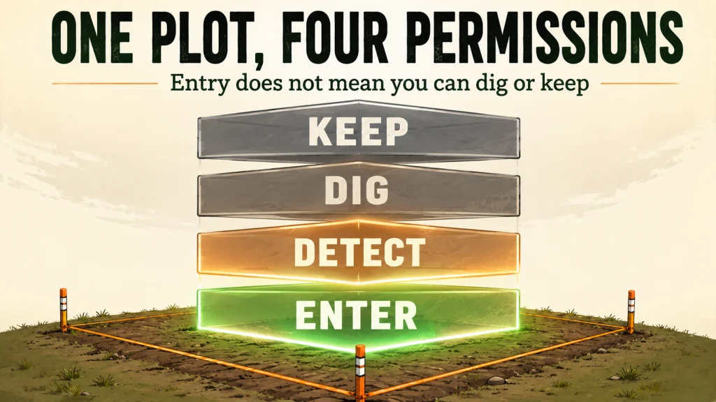
Ask whether detector possession and operation are allowed, whether probing or digging is allowed, whether objects may be removed, and whether a recovered object may be retained. Add hours, closures, approved zones, tool limits, permit conditions, and found-property procedures when they apply.
This prevents two common mistakes: assuming public access authorizes ground disturbance and assuming private permission to enter transfers ownership of finds. Access, activity, disturbance, removal, and retention are different permissions.
| Question | Required Confirmation | Not Enough |
|---|---|---|
| May I operate a detector? | Current rule or manager identifies the allowed area | The property is open |
| May I probe or dig? | Disturbance and tool limits are stated | Detecting is allowed |
| May I remove the object? | Collection and resource rules permit removal | The object looks modern |
| May I keep it? | Agency procedure, law, and private terms are satisfied | You recovered it first |
If a county employee says detecting is allowed, follow up about digging, landscaped areas, protected resources, and property that must be turned in. On private land, record the approved property, dates, exclusions, recovery expectations, and how finds will be handled before the hunt.

Garrett Pro-Pointer AT is a handheld pinpointer with three sensitivity levels and one-button controls for power, retune, sensitivity adjustment, and stealth mode. Its fast retune function narrows the detection field and helps tune out mineralized ground. The listing states that the unit is waterproof and submersible to 20 feet.
Check On AmazonIf you click this link and buy, we earn a commission at no additional cost to you.
Step 4: Put the Location on the Right Research Path
After identifying the owner, manager, boundary, and activity questions, choose the path that matches the current legal setting. Do not apply a beach rule to an inland park, a private permission assumption to a public easement, or a general federal statement to a unit controlled by a specific order.
Parks and Public Land
Local parks, state properties, BLM land, National Forest System land, National Park Service units, and Reclamation projects do not share one hobby rule. Agency, unit, designation, local order, resource status, and managing partner can change the answer. Use the process for checking parks and public land rules.
Beaches and Shorelines
Identify who controls the access, dry sand, wet sand, dunes, submerged area, and protected sections. Tides and sand movement affect target potential but never override closures or boundaries. Continue with verifying beach detecting zones.
Private Property
Confirm current ownership and the authority of the person granting access. Written terms are useful when the area, crops, livestock, buildings, dates, liability concerns, or division of finds could cause disagreement. Follow the method for researching and documenting private permission.
Historically Researched Leads
A historical lead is evidence that a current parcel or managed unit deserves attention, not a separate form of ownership. Old maps, aerials, newspapers, archives, and local records can reveal past activity, but current authority comes first. Use the process for ranking historically supported locations.
These paths can overlap. An old picnic grove may now be inside a county park, and a documented homestead may be private or federal. Classify the present legal setting first, then use historical evidence to rank the usable area.
Federal Land Requires the Exact Agency and Resource Context
“Federal land” is not one detecting rule. National Park Service regulations prohibit possessing or using metal detectors in park areas except for limited authorized activities. National Forest System and BLM lands can also be affected by resource-protection laws, local orders, special designations, closures, claims, and site rules. Reclamation recreation areas may be operated by another partner, so the name on a reservoir may not identify the office applying daily rules.
ARPA is often described too broadly. It protects archaeological resources on federal public lands and Indian lands and regulates excavation, removal, damage, and related activity. It does not automatically prohibit every detector use on every acre of federal land. Other regulations and orders may prohibit or limit the activity, so ask what the current manager allows at the exact location and for the proposed method.
If you encounter a possible archaeological, cultural, historic, sacred, burial, or human-remains context, stop disturbing the area. Leave objects in place, avoid publicizing sensitive coordinates, and contact the responsible manager or law-enforcement authority as directed.
Warning: Confirm federal and tribal land rules with the managing authority before publication and before every hunt. Rules, closures, permits, and management responsibility can change.
Build a Location Verification Card Before You Travel
A one-page card exposes missing answers better than a folder of screenshots. It should be specific enough to explain your plan if an employee, ranger, landowner, deputy, or neighbor asks what you are doing.
- Owner or manager: Current owner and office applying the rules.
- Exact location: Parcel, unit, zone, access point, and visible boundaries.
- Current rule: Official rule, code, written response, or permit condition.
- Permit: Issuer, dates, approved area, and conditions.
- Tools and disturbance: Limits on probes, digging, depth, turf, dunes, habitat, or vegetation.
- Hours and closures: Regular hours, events, seasonal restrictions, and emergency orders.
- Found-property procedure: Reporting, turn-in, documentation, or holding requirements.
- Cultural-resource stop rule: Conditions that require stopping and the correct contact.
- Verification record: Date, office, contact, map, and wording of direct confirmation.
Write “not confirmed” when that is the truth. A blank field means contact the manager, narrow the proposed area, or reject the location. For a beach, the card might mark approved open sand, dune and wildlife closures, access, hours, recovery limits, and the date the city confirmed the rule.
Red Flags That Require Direct Confirmation
These facts increase uncertainty. Stop relying on general summaries and contact the exact authority.
| Red Flag | Why It Matters | Next Check |
|---|---|---|
| Archaeological or historic designation | Resource protections may restrict detection, disturbance, removal, or location disclosure | Land manager or preservation office |
| Tribal or Indian land | Tribal authority, trust status, and cultural protections apply | Proper tribal or federal authority |
| Graves or possible human remains | Strict burial and human-remains laws may apply | Stop and contact required authorities |
| Public-private boundary | Access does not cross the legal line | Parcel and management boundary |
| Mining claim or mineral interest | Existing rights may affect access or activity | Current records and land office |
| Easement or right-of-way | Passage does not necessarily allow recreation or digging | Purpose, limits, and controlling parties |
| Protected habitat or special-use area | Seasonal, lease, event, or resource conditions may apply | Current site rules and closures |
| Temporary closure | Fire, flood, construction, nesting, or events can override normal access | Alerts close to the trip date |
| Conflicting maps | Layers may show different purposes or dates | Issuing offices and source records |
A county parcel layer, recreation map, and historical plat may each be accurate for a different purpose. Never make one record answer a question it was not designed to answer.

Rite in the Rain Weatherproof Top Spiral Notebook contains 100 pages of all-weather paper designed to repel water, sweat, grease, and mud. Its Wire-O binding is designed to keep open pages aligned and intact. The Polydura cover provides a flexible shell that protects field notes from scratches and stains.
Check On AmazonIf you click this link and buy, we earn a commission at no additional cost to you.
How to Find Metal Detecting Locations That Are Actually Usable
Legal access and target potential are separate filters. A legally available field with little evidence of past activity may be low priority. A historically rich site behind an unresolved boundary or resource restriction is unavailable until that issue changes.
After a location clears the legal filter, research why people gathered, worked, traveled, played, traded, camped, or lived there. Historical maps can show former roads, schools, fairgrounds, ferries, and buildings. Aerials can reveal removed structures, old paths, grading, fill, erosion, or field changes. Newspapers, directories, archives, and local records can add dates and uses.
Compare that activity with the approved area. A former gathering place has little practical value if it lies beyond the boundary. A private permission can cover a large parcel while the documented activity was concentrated around one lane, yard, or work area. Strong leads combine legal certainty, a field-identifiable boundary, repeated human use supported by more than one record, and practical access.
This order saves time. Research becomes useful when it ranks places you can lawfully and practically use.
Use This Final Pre-Trip Verification Workflow
Run every location through the same sequence, including places visited before. Ownership, permits, closures, and managers can change.
- Name the exact area: parcel, unit, zone, district, beach section, or marked boundary.
- Confirm ownership and management: identify both the property interest and the office applying current rules.
- Check current written rules: official pages, codes, orders, permits, closures, and unit notices.
- Ask about each activity: operation, probing, digging, removal, retention, tools, hours, and approved areas.
- Resolve red flags: protected resources, tribal land, graves, claims, easements, habitat, and disputed lines.
- Record the answer: source, date, contact, permit, map, and conditions.
- Recheck near departure: temporary closures, hazards, events, shoreline changes, and access.
- Carry proof offline: permit, written permission, map, and contact information.
- Stop when conditions conflict: a new sign, barrier, instruction, exposed feature, or uncertain line requires verification.
Finish with a decision: approve the location, narrow it to a verified zone, return it to research, or reject it. “Not confirmed” is useful because it protects the rest of the hunt.
Final Thoughts: Verify the Ground Before You Research the Finds
The best answer to where you should detect is not the place with the oldest map symbol or the most exciting local story. It is a location where the controlling authority, exact boundary, permitted activity, resource limits, and find procedure are clear enough to act on. Once that foundation is in place, historical research can help you choose among legal options instead of tempting you toward ground you cannot responsibly use.
I approach a location the same way I approached a boundary problem in survey work: identify the record, understand what it proves, find what it does not prove, and confirm the answer with the authority responsible for the land. Do that before every hunt, keep the answer with you, and be willing to walk away when the ground or the rules no longer match the plan.

Sea to Summit Waterproof TPU Guide Map Case uses PVC-free TPU with welded construction. Its ZipLoc top closure is designed to help keep the case sealed, and the Amazon listing states that it can survive submersion when closed properly. The material is described as flexible and resistant to UV exposure and extreme cold.
Check On AmazonIf you click this link and buy, we earn a commission at no additional cost to you.
Explore the Four Location Research Paths
Use the guide that matches the current legal setting of your location. Historical evidence can help rank any of them, but ownership and management determine which verification process comes first.
| Guide | What It Helps You Verify |
|---|---|
| Parks and Public Land | Agency, unit, designation, permit, local order, approved activity, and federal resource restrictions |
| Beach Detecting Locations | Ownership, shoreline management, approved sand zones, closures, tides, movement, and safety limits |
| Private Land Permission | Current owner, authority to grant access, the permission request, written terms, and find expectations |
| Historical Location Research | Maps, aerial imagery, newspapers, archives, local records, and evidence-based site priority |
Start with the guide that answers who controls the ground, then add the research needed to decide whether the approved area is worth your time.
FAQs
🗺️ Where can you metal detect legally near you?
Choose a specific property or recreation unit, identify its owner and manager, then verify operation, digging, removal, and retention through official rules or direct confirmation.
🏞️ Can I metal detect in a public park?
Public access is not permission to detect or disturb ground. Check the exact park’s current rule, permit, approved area, tool limits, and found-property process.
🏖️ Is metal detecting allowed on every public beach?
No. Authority can change across access points, dry sand, wet sand, dunes, submerged areas, habitat closures, and neighboring units.
🏠 Do I need written permission on private property?
Requirements vary, but written permission is the clearest record. Identify the property, approved area, dates, disturbance terms, and handling of finds.
📜 Does ARPA ban all metal detecting on federal land?
No. ARPA protects archaeological resources on federal public lands and Indian lands. Other agency rules and orders can still prohibit or limit detecting at a specific location.
🧭 What should I do when maps disagree?
Check each map’s purpose, date, source, and accuracy. Ask the parcel authority and land manager to clarify the usable boundary instead of choosing the line you prefer.
💍 Can I keep everything I find with permission?
No. Entry permission does not settle found-property rules, protected resources, removal rights, or private ownership terms. Confirm those before the hunt.
⚠️ What if I find possible human remains or a grave?
Stop all disturbance, leave the area in place, and contact local law enforcement and the responsible land manager or required jurisdictional authority.
Sources and References
- National Park Service, Policy Topics: Metal Detectors: current NPS policy reference directing readers to the regulation prohibiting possession or use of metal detectors in park areas.
- National Park Service, Archeology FAQs: official visitor guidance on digging, metal detector possession, detecting, and protected archaeological resources in National Park Service areas.
- Electronic Code of Federal Regulations, 43 CFR Part 7: current definitions, prohibited acts, permit framework, and scope for protection of archaeological resources on federal public lands and Indian lands.
- Bureau of Land Management, Can I Keep This?: official BLM guidance on cultural materials, collection limits, protected resources, and contacting the local office when rules are uncertain.
- U.S. Forest Service, Federal Laws Prohibiting Metal Detecting: official overview of metal detector use and federal archaeological and historic resource protections on National Forest System land.
- Bureau of Reclamation, Use of Land, Facilities, and Waterbodies: official explanation of authorization requirements and the role of permitted public recreation on Reclamation properties.