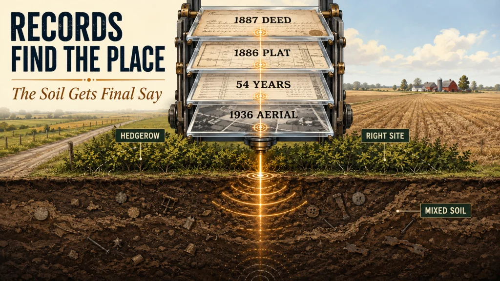
I found this site by following one 1887 deed from a county records room to an 1886 plat atlas, a modern aerial view, and a 1936 photograph. The records placed an old farmstead in a hedgerow that no longer looked important from the road, and the deed chain showed 54 years of continuous family occupation. After receiving permission, my first session produced period coins, a personalized pewter button, and the usual pull tabs. The research found the right place, but the disturbed soil proved that a strong paper trail cannot predict every condition under the coil.
The First Site I Researched Using County Records Began With an 1887 Deed
That site began with an 1887 deed describing a tract that contained a dwelling house, barn, and smokehouse. It also referenced a spring branch along the north boundary. I found the deed in the county records room while completing a title search for an adjacent parcel, and those few lines immediately gave me more than an owner name or acreage figure.
A dwelling, barn, smokehouse, and dependable water source described a working farmstead, not an empty tract. Within an hour, I had matched the property to an 1886 county plat atlas and located the current owner through the assessor database. What looked like an ordinary field on a modern road had started to become a specific, testable location.
This is not a general lesson about searching every old deed for treasure. It is the story of one property where separate records agreed closely enough to justify the next step. The useful part was not any single document. It was the way the deed, plat, ownership history, and aerial imagery narrowed the search together.
What the Records Showed Before I Ever Walked the Field
The 1886 plat atlas placed the farmstead in relation to a road alignment that still existed. That relationship mattered because old roads can shift, straighten, or disappear, while modern parcel lines and field edges can make a former homesite look unrelated to the landscape around it. I used the surviving road alignment as the fixed reference and worked outward from there.
When I compared the plat location with Google Earth, the likely building area landed in a hedgerow on the east edge of an open farm field. The hedgerow was easy to overlook from a vehicle. On the plat, however, it sat where the building group should have been, which made it more than a random strip of brush.
| Record or clue | What it revealed | How it changed my decision |
|---|---|---|
| 1887 deed | A dwelling house, barn, smokehouse, and spring branch were part of the tract description. | The parcel had a documented domestic activity area worth locating precisely. |
| 1886 county plat atlas | The farmstead’s position could be read against the road alignment. | I had a defensible starting area instead of a field-wide guess. |
| Deed chain | The same family occupied the property from 1887 to 1941. | Fifty-four years of occupation suggested repeated daily activity and a better chance of period targets. |
| 1936 aerial photograph | The foundation was still visible at the suspected location. | The aerial confirmed that the map interpretation matched a surviving physical feature. |
| Modern aerial imagery | The former building area had become a hedgerow beside an active field. | I knew what the site looked like now and where access would need to be discussed. |
The deed chain added the clue that made the site especially convincing. The same family remained there from 1887 through 1941, a 54-year occupation period. That did not guarantee old coins, but it raised the likelihood of repeated activity around entrances, paths, work areas, and outbuildings.
The 1936 image on Historic Aerials then showed the foundation still visible. At that point, four independent pieces of information pointed to the same part of the property. This is the basic reasoning behind researching metal detecting locations with historical records: each source should reduce uncertainty rather than add another interesting but disconnected fact.
The Permission Call Was About the Property, Not a Sales Pitch
Finding the likely homesite did not give me the right to enter it. I called the current owner, introduced myself by name, and explained that I had worked as a county surveyor in the area. Then I told them I had found a reference to their family’s historic property in the county deed records and was interested in detecting near the old homestead.
My surveying background opened the conversation in a way a cold request probably would not have. The owner could hear that I knew which property I was discussing, how I had identified the old building area, and why I was calling. I was not asking to wander across the farm looking for anything shiny.
- I identified myself and my local surveying background.
- I referred to the specific historic property shown in the deed records.
- I named the old homestead area rather than asking for unrestricted access.
- I waited for clear permission before treating the research as a place I could hunt.
Those details were specific to this call, not a script that will work with every owner. A professional connection may help establish credibility, but it does not replace respect, clear boundaries, or the owner’s right to decline. The broader principle is explained in my guide to researching property before requesting permission, but this particular conversation worked because I could show that I had done careful work on their parcel before contacting them.
The research also kept the request narrow. I wanted to examine one historic activity area near the former buildings, not the entire farm. That distinction makes a permission conversation easier to understand because the owner knows what you found in the records and what part of the property interests you.
What I Recovered During the First Session
The first session produced a 1911 Barber dime, a 1903 Indian Head cent, two wheat pennies from the 1920s, a pewter button with a hand-engraved initial, and six pull tabs. The pull tabs belonged in the story because research does not remove modern trash. It only improves the odds that the ground beneath it has a reason to hold older targets.
The Barber dime and Indian Head cent were the most immediately recognizable period finds, but the two wheat pennies gave me the cleanest confirmation. Their dates fell inside the documented occupation period and supported the conclusion that I was searching the domestic site identified in the records. They did not prove where every former structure stood, but they showed that the paper history and the recovered material were describing the same period of use.
Field Note: The hand-engraved initial on the pewter button mattered differently from the coins. A coin can move through trade and pass through many hands, while a personalized clothing item feels more closely tied to the people who used the property. I could not identify its owner from the information available, so I treated it as a personal trace, not a named historical attribution.
That distinction matters whenever a find seems to fit a compelling story. The date range, material, and location can support an interpretation, but they should not be stretched into certainty the evidence cannot carry. The records told me who occupied the tract and when. They did not tell me who lost each object.
The strongest result of the session was not one valuable coin. It was the agreement between the records, the mapped building location, the visible foundation in the 1936 aerial, and the dates coming out of the soil. That agreement showed the research had put me in the right place.
What the Records Could Not Predict About the Soil
The paper research located the farmstead correctly, but it did not reveal what decades of agricultural work had done to the ground. Soil near the hedgerow was heavily disturbed. Plowing had mixed layers, shifted objects away from their original positions, and made the target pattern less orderly than the clean historical layout suggested.
Targets below about 6 inches were masked by that disturbance during the session. That did not mean nothing remained deeper, and it did not turn 6 inches into a universal depth limit. It meant the site conditions reduced the clarity of deeper targets in the ground I was actually hunting.
This was the most useful correction to the story the records seemed to tell. Maps encourage us to imagine a fixed house, fixed paths, and objects falling into stable soil around them. Working farmland is not fixed. A correct historical location can still produce scattered targets, mixed depths, iron interference, and long stretches that sound less promising than the documented occupation would suggest.
That difference kept me from dismissing the research when the soil failed to behave neatly. The location work had answered where to search. The ground still controlled how the search had to be interpreted.
Why This Site Was More Useful Than Ten Random Visits
One afternoon in the county records room and one evening comparing maps and aerial imagery gave me a reason to contact one owner about one defined location. Ten random visits to casually selected ground might still produce targets, but they would not give me the same control over where I spent my limited field time.
The real advantage was accountability. Before asking for access, I could explain what made that small area worth testing and what evidence would count against my interpretation once I reached the field. That kept the project from turning into a story I wanted to believe simply because an old document looked promising.
That is the standard I now apply when research starts to feel productive. A useful source should change a decision: narrow the search area, clarify the likely period, identify the correct owner, or expose a landscape feature that can still be checked. Interesting history is not automatically useful field research.
This property also showed the method’s limit. Research can improve where I spend my time, but it cannot guarantee what remains, how the ground has changed, or whether access will be granted. Its value is replacing random searching with decisions that can be explained and tested.
Final Thoughts: Let Separate Records Point to the Same Ground
No single record found this site for me. The useful conclusion came from several sources agreeing closely enough to justify a precise permission request and a focused first session.
The finds supported that conclusion, while the disturbed soil corrected the neat version of the story suggested on paper. That is why I trust documented research without treating it as a promise: it gives the coil a defensible place to start, and the ground gets the final word.
FAQs
🗂️ Can county records really help locate an old homesite?
Yes, when a deed description, ownership chain, plat, and later imagery can be tied to the same modern parcel. One record may only provide a clue, so I look for agreement between separate sources before treating a location as field-ready.
🗺️ Is an old plat map enough to decide where to detect?
Not by itself. A plat can place an owner or building area, but road changes, mapping scale, and modern land use can shift how that location should be interpreted. I compare it with deeds, current parcel information, and aerial imagery.
📞 Why contact the owner before visiting the suspected site?
Historical research does not create access rights. The current owner controls permission, and a precise request is easier to evaluate than an unexpected visit or a vague request to search the whole property.
🪙 Did the coins prove the exact location of every farm building?
No. Their dates supported the documented occupation period and confirmed that I was working the correct domestic area. They did not establish the exact footprint or use of every former structure.
🌱 What if a researched site has heavily disturbed soil?
Treat the location research and the soil diagnosis as separate questions. The records may still be correct even when plowing has scattered targets, mixed depths, or reduced the clarity of deeper signals.
📷 Does a historical aerial image guarantee a foundation is still there?
No. It shows what was visible when that image was captured. Later farming, grading, construction, vegetation, or erosion may have altered the site, so the image should guide inspection rather than replace it.
Sources and References
- Library of Congress, County Land Ownership Maps Through 1900: background on the historical county landownership maps and atlases used to connect owners, roads, parcels, and former building locations.
- National Archives, Land Entry Case Files and Related Records: context on land-record research and the need to continue ownership research through city, county, and state repositories.
- Historic Aerials, Frequently Asked Questions: information on using historical aerial imagery, topographic maps, timelines, and overlays to examine how a property changed across decades.
- Google Earth Help, View a Map Over Time: instructions and limitations for comparing current and historical imagery through the Google Earth timeline.
- National Archives, Aerial Photography: background on historical aerial photographs as records of physical and cultural landscape conditions at a particular time.